


Le Theil rando A

nolsim
User

Length
11.3 km

Max alt
94 m

Uphill gradient
114 m
Km-Effort
12.9 km

Min alt
51 m

Downhill gradient
127 m
Boucle
No
Creation date :
2025-05-13 12:24:40.31
Updated on :
2025-05-13 14:55:35.761
2h30
Difficulty : Easy

FREE GPS app for hiking
 SityTrail
IGN / Geographical institutes
SityTrail Plus
The world is yours!
About
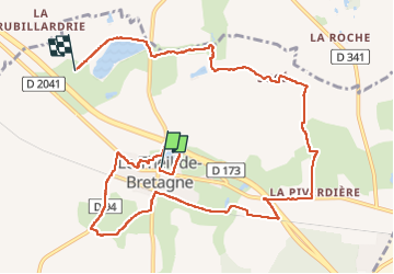
Trail Walking of 11.3 km to be discovered at Brittany, Ille-et-Vilaine, Le Theil-de-Bretagne. This trail is proposed by nolsim.
Positioning
Country:
France
Region :
Brittany
Department/Province :
Ille-et-Vilaine
Municipality :
Le Theil-de-Bretagne
Location:
Unknown
Start:(Dec)
Start:(UTM)
617355 ; 5308705 (30T) N.
Comments